IndoorAtlas enables accurate cross-platform Indoor Positioning of smartphones by fusing all available information sources, including:
• Geomagnetic fingerprint maps
• Pedestrian Dead Reckoning with gyroscope and accelerometer (IMU sensors)
• Wi-Fi signals
• Wi-Fi RTT/FTM signals
• Bluetooth beacons
• Barometric height information
• Visual-inertial information from AR core
IndoorAtlas works with any indoor maps, including Google Maps.
MapCreator 2 provides an efficient way to enable geomagnetic-fused indoor positioning in your chosen location/venue. This app records sensor data (geomagnetic landscape, WiFi, BLE and other sensory data) inside a building and uploads it to IndoorAtlas’ cloud platform
The steps of successfully deploying IndoorAtlas technology are:
1. Setup: Signing up and import floor plan images into https://app.indooratlas.com
2. Map: Mapping and optional beacon setup
3. Build: Integrating the SDK into your indoor-location-aware application
MapCreator 2 provides the following benefits:
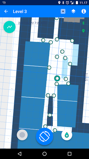
• Quick fingerprinting experience for enhanced productivity and efficiency
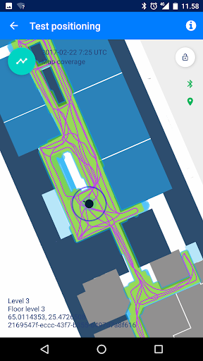
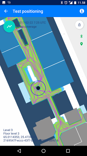
• Quick and simple position testing (shows blue dot on the floor plan)
• Automatic mapping quality analysis for quality control in MapCreator and in https://app.indooratlas.com
• Mapping with Android enables positioning service also for iOS
• Allows free walk and stops during data collection
Following the successful mapping of your location/venue, IndoorAtlas’ positioning service will be available for your app on both Android and iOS smartphones. Once mapping is complete, you can download the IndoorAtlas SDK for free and start building location aware apps for Android and iOS.
For guides, please visit : https://support.indooratlas.com/
A short tutorial video is also available https://www.youtube.com/watch?v=kTFxvTrcYcQ
Device compatibility:
• Fingerprinting requires WiFi, magnetometer (compass), accelerometer and gyroscope (hardware sensor, not virtual gyroscope) sensors
• Positioning works with any Android 5 or later.
Some example smartphone models for producing production quality maps:
* Galaxy A55 5G
* Galaxy Tab A8
* Galaxy S23 5G, S23 Ultra
* Galaxy S22
* Samsung Galaxy S10, S20, S20+, S20 Fan Edition
* Galaxy Tab S5e
* Xperia XZ Premium
* OnePlus 7 Pro GM1913
* OnePlus Nord AC2001
* OnePlus Nord AC2001
* OnePlus 9
* OnePlus 10 Pro 5G
* Google Pixel 6, 6 Pro, 6a,5,4,3,2,1 and XL
* Samsung Galaxy XCover 5
* Samsung Galaxy A32 5G
* Samsung Galaxy Note20 5G
If you are considering buying a device that is not on the above list, a good up-to-date starting place is Google's AR support device list, as those devices typically have high quality sensors:
https://developers.google.com/ar/discover/supported-devices
• Email us your feedback on the experience at support@indooratlas.com
Sign up for free at https://app.indooratlas.com/login
Terms of Service: https://www.indooratlas.com/terms/
IndoorAtlas Mobile License Agreement: https://www.indooratlas.com/mobile-license/
Show beacon locations in analytics,
Show observed beacons during positioning,
Major speed improvements in map rendering,
IndoorAtlas SDK 3.7.0
Internal improvements
Updated IndoorAtlas SDK to 3.4,
Outdoor ground truth collection support,
Scalability improvements for large venues,
Removes obsolete contacts permission requirement
Uses IndoorAtlas SDK 3.3
Shows count of recorded paths pending upload
Reminds to generate map if new paths have been recorded
Bug fix for cloud analytics in positioning view
Chinese language support added
Updates to latest IndoorAtlas positioning SDK 3.2
- Update to use IndoorAtlas SDK 3.2
- Support cart mode testing (Beta)
- Minor bug fixes
- Updates to IndoorAtlas positioning SDK 3.1.1
- Improvements to positioning test view
* Improved Diagnostic mode i.e. test positioning with marking ground truth
* Fix stuck path uploads in rare cases
* Performance improvements related to environments with hundreds of simultaneously heard BLE beacons
- Update to IndoorAtlas SDK 2.9.3
- Show cloud Wifi environment quality analytics
- Show cloud Magnetic mapping quality
- Show amount of seen beacons and Wifi APs for each recorded path
- Show warning when no beacons seen in recorded path
- Positioning diagnostic mode guide and improved usability
- Performance improvements of real time fingerprinting analytics
- Bug fix: floor plan did not load in some cases
Updated IndoorAtlas SDK to 2.8
Bug fixes
Improvements to mapping warnings
- Endpoint change, previous app versions will be deprecated eventually
- Few new recording time sanity checks
- Performance tuning and bug fixes
- bug fixes
- Crash case -fix at positioning view
- Targeted Android SDK version incremented
- Minor bug fixes
User can now toggle between indoor only- and indoor/outdoor positioning modes and select diagnostic mode
This release also introduces major changes to the analytics information;
- application now calculates magnetic-, WiFi- and beacon analytics in realtime from data collected with the device
- uploaded paths -information is synced with backend and it also displays paths collected with other devices
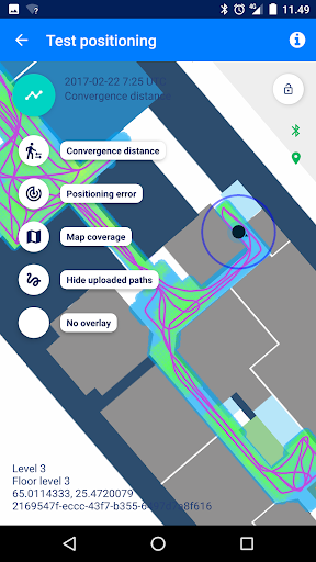
- positioning view has a "diagnostic mode" to help with reporting positioning performance issues
User can now toggle between indoor only- and indoor/outdoor positioning modes and select diagnostic mode
This release also introduces major changes to the analytics information;
- application now calculates magnetic-, WiFi- and beacon analytics in realtime from data collected with the device
- uploaded paths -information is synced with backend and it also displays paths collected with other devices
- positioning view has a "diagnostic mode" to help with reporting positioning performance issues
User can now toggle between indoor only- and indoor/outdoor positioning modesThis release also introduces major changes to the analytics information;- application now calculates magnetic-, WiFi- and beacon analytics in realtime from data collected with the device- uploaded paths -information is synced with backend and it also displays paths collected with other devices- map coverage of latest generated map is still available- also random bug fixes
User can now toggle between indoor only- and indoor/outdoor positioning modesThis release also introduces major changes to the analytics information;- application now calculates magnetic-, WiFi- and beacon analytics in realtime from data collected with the device- uploaded paths -information is synced with backend and it also displays paths collected with other devices- map coverage of latest generated map is still available
- walking speed -sanity check tuned a bit- no need for the READ_EXTERNAL_STORAGE -permission anymore- more comprehensive mapping guide .pdf now available for download directly from the app- random bug fixes
- improvements to map-data validation checks- bug fixes
- the app can be used to test positioning performance on wider array of devices (HW gyroscope and magnetometer are still required for mapping)- positioning testing -feature can now be accessed via the application side menu- user can select between standard- and low power positioning modes- location surroundings are now displayed with MapBox -maps- memory optimisations- bug fixes
- the app can be used to test positioning performance on wider array of devices (HW gyroscope and magnetometer are still required for mapping)- positioning testing -feature can now be accessed via the application side menu- user can select between standard- and low power positioning modes- location surroundings are now displayed with MapBox -maps- bug fixes
- the app can be used to test positioning performance on wider array of devices (HW gyroscope and magnetometer are still required for mapping)- positioning testing -feature can now be accessed via the application side menu- user can select between standard- and low power positioning modes- location surroundings are now displayed with MapBox -maps
- used IA SDK version upgraded- bug fixes
- fix WiFi scanning functionality in certain devices- new checks for floor plan placement and check-in frequency- bug fixes